
- Home
- Mission
MSNMission overview
Built for the ground you choose
A desktop application that turns a published land-cover method into something a researcher can run on a chosen area, on their own machine, and question.
01Objective
Farm to landscape, under a fixed protocol
TERRA classifies land cover over an area of interest from Sentinel-2 L2A time series, and reports where that classification is wrong rather than only how much of it is right. Around the classifier it carries further products for the same area: rainfall routed over the terrain, a flood envelope, solar and wind resource read beside the electrical grid, and a canopy simulation grown from the crop that was classified.
Farm- and parcel-scale work often sits between two extremes. Scripted cloud notebooks are powerful but hard to hand to a collaborator who wants a map. General desktop GIS does not ship a published spectro-temporal pipeline with run history and model comparison. And full scene downloads are heavy when only a small polygon matters.
TERRA is aimed at the space between: remote-sensing and agronomy researchers and students who need reproducible, area-scale classification on a local machine, without operating a hosted backend.
It is
- Reproducible land-cover classification over an area you choose
- An explicit account of where a map disagrees with its reference
- Local: no account, no server, no full-scene downloads
- Built around a published, fixed protocol
It is not
- A general-purpose GIS: QGIS already covers that ground
- A continental production system: Earth Engine already covers that
- A hosted service with a multi-user backend
- A field survey: the reference is a map, not the ground
02Operations
The map, and the studio over it
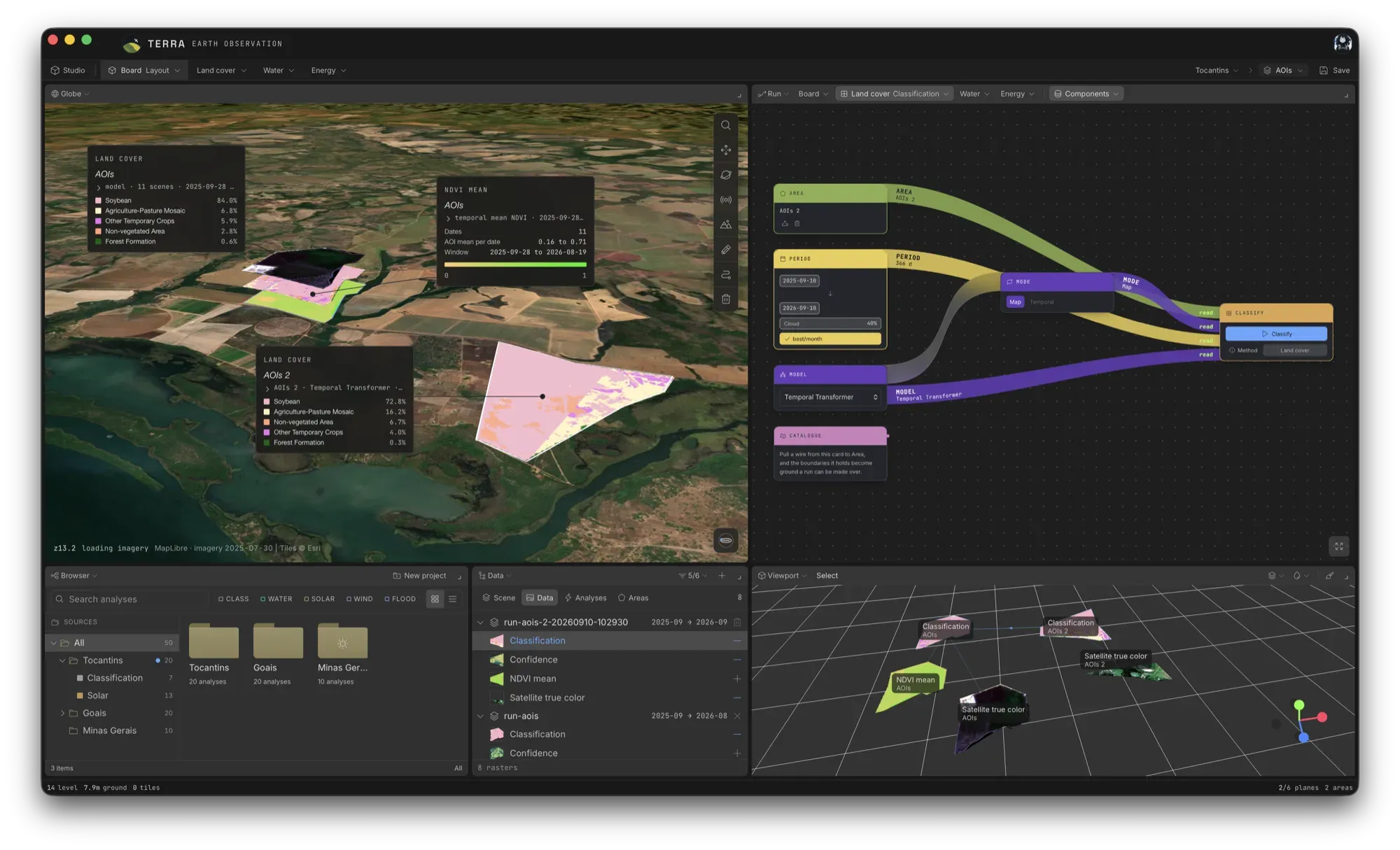
Work starts on the globe: you draw or import an area, set the acquisition window, pick a model and start a run. On the board, that run is laid out as cards wired together: area, period, mode and model feeding the classification.
The studio opens over that map and closes back onto it. The screen divides into the panels a question needs, and more than one area fits on the same board, so two farms, or the same farm in two seasons, can sit side by side. Five arrangements ship ready: Layout, Compare, Diagnose, Data and Simulation.
It exists because a map cannot do this. A map puts things where they are, so two areas hundreds of kilometres apart cannot be set beside each other on it.
03Architecture
Three layers,
one machine
The split keeps the published scikit-learn and rasterio stack intact, while giving it a native interface and installable releases.
- L1
Interface
React · TypeScript · MapLibre GL · three.js
A map and a globe for drawing or importing areas, and the studio: a board of panels arranged for the question at hand.
- L2
Shell
Wails · Go · SQLite
Owns the window, supervises the sidecar, streams progress, and keeps every run on the local disk.
- L3
Sidecar
Python 3.12 · rasterio/GDAL · pystac-client · scikit-learn · PyTorch (optional)
Queries STAC, windows the COGs, builds features or embeddings, classifies and writes rasters. It speaks JSON over standard I/O.
04Ground stations
What it reads
Imagery comes from a public catalog and is read on demand. Reference, weather and terrain come from open sources.
| Source | Used for |
|---|---|
| Microsoft Planetary Computer STAC | Sentinel-2 L2A imagery, read as Cloud-Optimized GeoTIFF windows |
| MapBiomas Brazil, Collection 10 (2023) | Land-cover reference, where the area intersects Brazil |
| NASA POWER | Hourly radiation and meteorology |
| MERRA-2 | Wind, on a 0.5 × 0.625° cell |
| ONS open data · ANEEL register | What each plant generated and was told not to, the transmission network, and where each plant is |
| Copernicus DEM GLO-30 | Slope, aspect and horizon, and the terrain water is routed over; with NASADEM, ALOS and GLO-90 for the flood envelope |
| Nominatim · OpenStreetMap | Place names |
| Esri World Imagery · EOX Sentinel-2 cloudless 2025 | Basemaps |
05In research
On the pad
Methods are prototyped and validated in dedicated research work, under literature review, implementation and tests with academic supervision. These are still there.
- In research
Change detection
Pairwise and multi-date spectral and NDVI change over the area: vegetation gain and loss.
- In research
Crop stress diagnostics
Per-date stress, phenological stage and growth against the expected calendar.
- In research
Class-41 decomposition
Opening the residual 'other temporary crops' class into crops that can be named.
- In research
Topography workflows
Terrain-driven analysis beyond the slope, aspect and horizon already in use.
To collaborate on a method, write to joao_leonardi.melo@somosicev.com. Bugs, UX and packaging go to GitHub Issues.